

Lookout Mountain
The Lookout Mountain loop has a lot to offer. It is fun, challenging without being scary, and beautiful in every season. Riding here in the George Washington National Forest feels like an escape from society without actually having to go all that far.
This trail system went through a huge relocation in 2012, and the hard work that everyone did is apparent around every turn. What was created is the trail that we now know and love as “Lookout,” and it’s always one of the first mountain bike rides we recommend to friends, customers, and visitors. More words on all of that outstanding work later.
Our route is the classic way of riding Lookout. It is 13 miles with 2100’ of climbing.


Photo Credit: Jess Daddio
Parking
Parking is available at The Wild Oak Trail parking lot in the National Forest. It is just down the road from the Stokesville Market and Stokesville Campground, about a 40 minute drive from Harrisonburg. If that lot is full, which can sometimes happen on a super nice weekend, there is parking up the road in several spots, as well as off of Tilghman Rd.
The Wild Oak Trail / Lookout Ridge
The Lookout Mountain route is mainly on The WIld Oak Trail, a National Recreation Trail marked by a white blaze and red/white/blue “NRT” placards. To get to the trail, you’ll head up the road from The Wild Oak Trail Parking lot, and roll along pavement for just over 5 miles. Around 3.7 miles in, you’ll have a fun pavement descent to a split in the road - make sure to stay to the left here, and watch for traffic as you make that turn.

A “tunnel” of beautiful forest as you make your way to the trail.

The left hand turn you’ll want to take at the end of the first road.

This is that same first road of the ride, but in the Fall. Beautiful in every season, right?! :)
The pavement will turn to gravel, and you’ll pass by the North River Campground. At mile 5.4, you’ll make a left turn onto the Hankey Mountain Forest Service Road. There is a small path on the left to get around the Forest Service gate. From here it is a 2 mile climb to the turn onto trail Lookout Mountain Trail, aka The Wild Oak Trail.
* A worthwhile note: At the intersection to turn left onto Lookout Mountain, you’ll see that it is marked as Trail 425A. The trail for Lookout will then turn into Trail 716. You want to take that left onto 425A and then after that, follow the signs for Trail 716 to stay on Lookout Mountain/The Wild Oak Trail. *
It may seem like a lot, all this pavement plus a 2 mile climb to get to the trail, but it is worth it!

The gravel road that will take you past the North River Campground and to the turn onto Hankey Mountain service road.

Hankey Mountain

You’ll see there is a gap in the Forest Service gate on the left; it’s fairly easy to ride through, and means there’s only two miles left until Lookout!

Two miles up from the Hankey Mountain sign, you’ll see this sign and that the double track splits two different directions. You will want to take the left split to get to Lookout Mountain Trail!

The Shaffer Hollow intersection
There are two trails on the right that go off of trail 716: Bear Draft (535) and Shaffer Hollow (513). For this ride you’ll want to stay to the left to continue on 716 in its entirety. Both of these offshoots would take you down to the fire road that connects Stribling Springs to the Stokesville Campground. Many cyclists will know Shaffer Hollow as the final trail that stands between them and the finish line of the Shenandoah Mountain 100. It is a steep, loose descent for that event, but if you decide to climb it, Shaffer Hollow offers a shorter version of the Lookout Loop (about 9 miles). To get to it you have to go through the Stokesville Campground, so make sure you’ve done you’re due diligence and paid for a day pass to go through that private property.

Trail 716 marked by the White Blaze in a tree tunnel of awesomeness!
Photo Credit: Jess Daddio
The WIld Oak Trail - Ok, you’ve finally made the turn onto Trail 716! Get ready for some super fun rollers! You’ll hit some grassy/more dirt than rock short climbs and downhills for about 2 miles from where you turned onto Lookout Mountain, and then pass the sign that would take you down Shaffer Hollow. After this point, the trail starts to get rocky and more variable. Make sure to take in the views that peak through the trees on either side of the ridge! You’ll get a view of the Shenandoah Valley on your right, and more of the George Washington National Forest on your left.

Sunrise from the ridge on Lookout
Photo Credit: Jess Daddio

Photo Credit: Jess Daddio
The descent & Overlook
About 9.5 miles into the ride, you’ll reach the descent down the mountain. One of my favorite things about this trail is that it has features that are on the technical side, but they aren’t scary. If a rider wants to opt out of riding a section, it’s not like a game of twister trying to maneuver your bike over/around stuff, while also trying to not fall off the side of the trail. And the way this trail has been reworked encourages riders of multiple skill levels to try something new or push themselves to ride something they maybe didn’t see themselves being able to do.

Photo Credit: Jess Daddio
On all of these ‘Iconic Rides’ there’s always a section that feels extra magical. This section of trail, from the overlook and all the way down to the bridge over the North River, is the magical fairyland. In the Summer, the sunlight shines playfully through the leaves as you fly over rocks, down steep chutes, and around the trees. You’ll definitely want to stop and take it all in at the Overlook before finishing out the ride. It’s a great little spot to snack, take in the sounds of the wind and the river, and enjoy being outside (and maybe take pictures of cool bugs that hang out on the rocks!). :)

Photo Credit: Jess Daddio

Photo Credit: Jess Daddio

Photo Credit: Jess Daddio

Photo Credit: Jess Daddio
The Bridge
After the overlook, you’ll know you’re getting closer to the bridge over the North River by the increasing number of rocks; there’s a rock “dome” that you ride over that indicates the start of this section. I really like this part of the trail, and it is probably the most technical part of the ride. The rocks are just large enough to feel extra bumpy, and are positioned so that you have to stay on top of it with where you’re putting your bike. As you continue to descend, those smaller rocks become boulders, and there’s one small spot just before the end of the trail that is extra special. You’ll know it when you see it. It’s an odd clumping of boulders that you really just have to get over, you can’t go around - it’s easier said than done. I haven’t ever cleared this rock spot, but know that with practice, a boost in confidence, and maybe some help from friends, it’s achievable.

Photo Credit: Jess Daddio

Photo Credit: Jess Daddio

Photo Credit: Jess Daddio
At the bridge, you’ll see a trail to your right and a trail to your left. The trail to your left is trail 538, North River Gorge, and the trail to your right, is a footpath to the Girl Scout Camp down the road from the Wild Oak Trail Parking Lot.
You won’t be able to ride across the bridge over the North River, it’s a little narrow, so you’ll have to walk your bike. It’s a nice forced slow down to take a look out over the river and appreciate the Public Lands we have.

Photo Credit: Jess Daddio
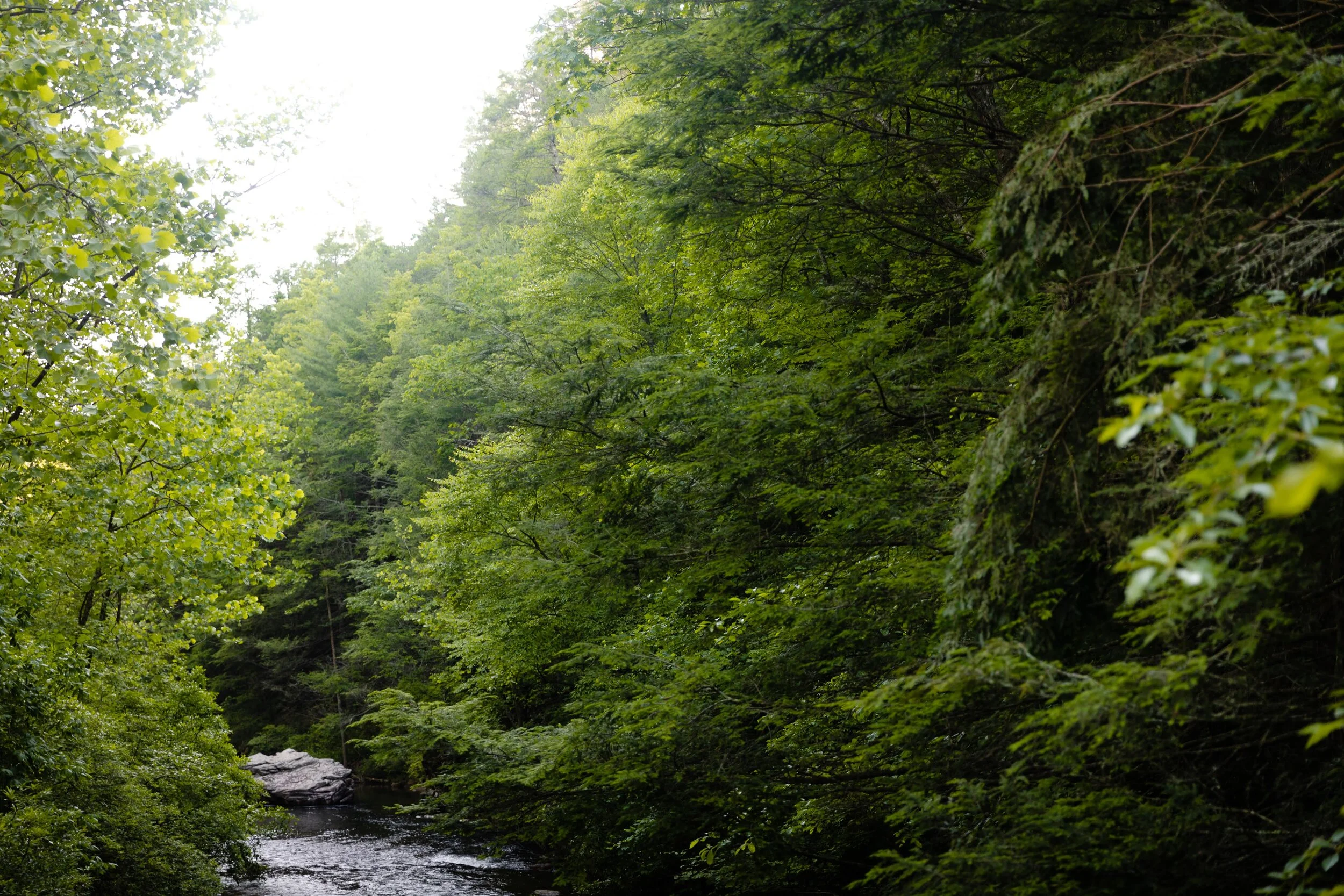
Photo Credit: Jess Daddio
After the bridge, you’ll have some rooty double track to ride that will take you back to the road you started on (stay to the left when you reach a split in the trail, just before reaching the road). There is an option of crossing over the road and adding just a little extra trail to your ride. This small section of singletrack will take you past the Grindstone Trailhead and directly to the Wild Oak Parking lot. When we went to take pictures for this write-up we were happily surprised by a world of giant ferns! Ferns are fun, and we don’t usually see them in these numbers here, we mostly see something like this over in West Virginia or central Pennsylvania. So yeah, it’s worth it to add that little bit of trail, you never know what you might see!

Photo Credit: Jess Daddio

Photo Credit: Jess Daddio

Photo Credit: Jess Daddio

Photo Credit: Jess Daddio
Trail work / Re-route / re-location
I wanted to include some words from Kyle Lawrence, Director of the Shenandoah Valley Bicycle Coalition, about all of the work that went into making Lookout what we know it as today. This is a project that highlights the importance of the Shenandoah Valley Bicycle Coalition in what it does not just for cyclists, but for all folks looking to recreate in public areas and on public lands.
“The Coalition has administered more than $500,000 of grant funding to improve trails on the North River District of the George Washington National Forest. The Lookout project was part of our second grant and was administered in 2012 along with the Tower Trail and Tillman West re-routes on Narrowback Mountain. We are working on our fourth trail building grant with tentative plans for a trail re-route on Narrowback Mountain to connect to the Wolf parking lot. Pending Forest Service approval, construction could begin in early 2021. More info on the Narrowback project: https://svbcoalition.org/narrowback-trail-build.
Lookout’s re-location was prompted for a few reasons. The old portion of the Wild Oak trail over the top of Lookout Mountain was very steep and extremely eroded. It posed a sustainability issue from an environmental perspective but even more importantly, it provided a very poor trail visitor experience. With loose rocks and very steep grades, most people had to walk this section of trail. When looking around the National Forest for areas where we could improve our trail system, this particular section stood out as a segment that was located near a popular parking area, on the edge of the Forest and closer to the Valley and near other mountain bike hot spots such as Stokesville and Narrowback Mountain. We also have not successfully built new trail on the National Forest due to many long and complicated issues largely centered on the Forest Service massive trail inventory and complete lack of funding to maintain their trails. As a result, the Forest Service does not want to add any new trails to their system. Our workaround had been to identify very steep and unsustainable segments of trail and then relocate them onto sustainable grades. In turn, we close or decommission the original alignment in order to allow nature to restore the trail to a more sustainable state.
Trail Dynamics (a professional trail building company from Brevard NC) spent nearly six weeks on the Lookout project with several workers running equipment for five days a week. The Lookout project was completed with mini-excavators and walk-behind earthmovers. The rock work was largely placed with a mini-excavator outfitted with a thumb on the bucket. Hand crews then cleaned up behind the machines. The cost of the project was more than $65,000 and funded with a Recreational Trails Program grant through the Virginia Department of Conservation and Recreation. The Coalition secured the grant, put the contract out to bid, and then managed the contract and the entire project. In addition, the Coalition covered 20% of the total project cost through a mix of fundraising and volunteer work hours that counted as in-kind match.
The bulk of the Lookout project was largely completed by professionals. The rocky technical nature of this build would have taken our volunteer crews many years to complete. This is particularly true given the long hike required to reach the construction site. Some volunteer work was accomplished, the Coalition spent a full Saturday during the 2012 Shenandoah Mountain Bike Festival working on the lowest reroute with volunteers and accumulated 250 volunteer hours on that section. Other work on Lookout over the past decade from small maintenance fixes and more add up to an additional 600 volunteer hours when accounting for the administrative work involved with managing the grant and contract for the professional build. The Lookout Project took six weeks and was completed at the same time as the Tower trail and the Tillman West Trail on Narrowback Mountain.
As an organization, we believe deeply in the importance of volunteer work on our trails to help people connect to their local trails while developing ownership. That said, we are careful with where and how we ask for volunteer help. In the case of Lookout, volunteers would need to drive upwards of an hour to reach the Wild Oak parking lot then hike in over an hour before moving any rocks or dirt. Once the work begins, volunteer work sessions are typically limited in scope and time. For these reasons, we work hard to secure grant funds and raise money to hire professional contractors for National Forest projects. This allows us to make substantial improvements to our trails in a comparatively short period of time. If the 15 people who showed up for trail work in the National Forest instead spent the same number of hours on writing a grant and fundraising the amount of work that could be accomplished might be 25x what they would have achieved during that trail work session. We will always hold volunteer trail work but often try to focus our efforts on trails that are more accessible like Hillandale Park or the Massanutten Western Slope. The National Forest is the perfect location for professional trail builders to make a big impact given the remote nature of the work.”

This picture highlights just one of the many spots of awesome rock work completed during the SVBC re-location of Lookout.
Photo Credit: Jess Daddio
Extras
Food - Don’t forget to stop by the Stokesville Market for snacks! They also sell passes to access the Stokesville Campground’s swimming hole (a perfect spot to hit up after riding Lookout!
The Photographer: Shout out to Jess Daddio for the amazing pictures of our Iconic Rides! Check out her website or Instagram (@jessdaddio)! She is an awesome woman and an inspiration!

Old Parkersburg!
Old Parkersburg is a gravel road connecting the town of Deerfield to the outskirts of the city of Staunton. It is a wonderful gravel climb with beautiful landscape, fun terrain, and many fun ways to ride to it.
The route we share for Old Parkersburg hits all of my favorite snack spots, features some pot-bellied pigs and cute cows, and never stops amazing with the valley and mountain views. This route should really be known as “Kelly’s snack ride” because that’s actually what it is, haha. :)
An 80 mile ride, with 5,200’ of elevation, the Old Parkersburg route rolls along nicely, and keeps ya smiling the whole way.


Key Route Points
Food / Snacks
Food/water/snacks/hangout spots… whatever you want to call these oases, can be found at 3 spots directly on the route. Two of these spots are local gas stations that are near and dear to my heart.
Snack stop #1: The Stokesville Market
The Stokesville Market is at mile 20 on this route. I usually stop to eat 2nd breakfast here - also known as THE BEST CINNAMON ROLL ever! I’ve also had delicious pop, pizza, chips, candy, and chocolates, but about 4 months ago, these locally made cinnamon rolls showed up, and since then I have bought one of these tasty treats every single time I pass through Stokesville. I highly suggest you give these a try. And if the Market only has the large family pack size out, feel free to politely ask for a single, one of the employees will cut a few up for you.
ALSO at the Stokesville Market, you may be lucky enough to observe the pot-belly pig family that lives at one of the houses behind the Market. THEY ARE SO CUTE, and roam freely around the store and neighboring field. If you don’t see them out front, take a peak behind the store and you’ll probably spot them.

Yes I did purchase TWO cinnamon rolls, and I do not care if you judge me. :)


Snack Stop #2: Mountain View Store / aka West Augusta Store
If you chose to skip the 2nd breakfast/snack options in Stokesville, OR you find yourself hungry sooner than you anticipated, at mile 28 you’ll ride past the Mountain View store at the intersection of rt250 and Deerfield Valley Rd.
This store is home to the MOUNTAIN DEW CAKE. Yep, you heard right: MOUNTAIN DEW CAKE.
Found in the pastry case directly to your left after walking in the store, a slice of mountain dew cake will be calling your name. Don’t knock it til you’ve tried it - it basically tastes like pound cake, but somehow is SO MUCH better. The Mountain View General store also has all of your basic ride needs, as well as some local products like maple syrup and jerky. This is the spot Chris usually grabs a snack - he’s partial to the mini pizzas they keep hot and ready. Lots of choices for whatever food mood you find yourself in.
Make sure to take a look at the ET-like figure set up in front of the store. Though I don’t know that it is supposed to be like ET because of the sign mentioning “Marg” beneath it, I like it’s quirky-ness and am amused by it.

THE mountain dew cake!


Snack Stop #3: Jake’s Convenience & Subway
Though I don’t have any pictures for you of this convenience store, it’s worth mentioning because it’s right around mile 55, it’s after you’ve climbed Old Parkersburg, and there’s still 25 miles to go before you get back home.
I like to hit up the ice cream and Red Bull coolers here - the chocolate chip ice cream sandwiches and Cranberry flavored Red Bull are some favorites.
This convenience store also just happens to be conveniently located directly across from the road you will continue your ride on to head home.
Special / noteworthy spots
Stokesville (not just for snacks)
Stokesville used to be a booming railway town in the early 1900s, and the mountains were almost bare from the logging by the time the town was in decline. Not much history can be found on Stokesville, but Dr. Clarence R. Geir has put together a wonderful presentation on what is known of the town that can be found on the Friends of Shenandoah Mountain webpage.
Two of the easily seen remnants of the railways that used to exist here can be found at the entrance to the Stokesville Campgound - a depot house and caboose sit on the road right after passing the bridge over the north river, welcoming campers and cyclists to a glorious time spent outdoors.


Stover Shop Rd
The first gravel road of this route, Stover Shop feels almost like ‘little West Virginia’. You ride between mountain ridges with smaller pastures on their sides. There are some beautiful homes placed along this road, and no shortage of wildlife and silly cows.


Old Parkerburg
And now we get to it - the namesake of this ride: Old Parkersburg Rd.
Riding this road is relatively new to me. I only started venturing to it in the last 6 months. Rocktown’s owner, Ken, LOVES this road, and after hearing from him about it for years, I finally decided to check it out, and wished I had listened to him much earlier.
You’ll turn onto Old Parkersburg right around 36 miles into the ride. It will meander a bit as pavement and then turns to gravel just before you start to climb. The climb is 1.5 miles long. It’s not a harsh climb, and the gravel gets only slightly loose in a few spots. You start out under a tree canopy and then as you ascend, mountain ridge views start to poke through on your right. If you were to mountain bike on that ridge it would take you to a super cool spot called Elliot’s Knob (more on that some other time). On your left as you climb, keep your eyes open for some pretty flowers, small caves, and jumping chipmunks!
The descent down Old Parkersburg to Buffalo Gap is a lot of fun, and has a pretty stream running next to it. Keep in mind to watch out for automobile traffic - though there are fewer cars/people out here, it doesn’t mean they no longer exist.

Crossing over the West Dry Branch at the beginning of Old Parkersburg Rd


Extras

The Ride Home : After Old Parkersburg, you’ll hit one of my favorite roads - Middle River. Aptly named, you’ll ride next to the Middle River for a few miles - it’s beautiful.
Add-on into Staunton: Feel free to visit Staunton, or extend your ride, by heading East on rt254 instead of crossing over it (Mile 51-ish). There are some great restaurants and coffee shops to stop at (Reunion Bakery is a favorite spot). Connect back to Middle River Rd by way of riding through Gypsy Hill Park to Shutterlee Mill, left on Luckstone Rd, right on Union Church Rd, and then right onto Middle River.
Caution on rt 250 between Stover Shop and Deerfield Valley: I highly recommend having a bright taillight on for this section of road (I always have mine going). It’s the one road on this route that has some faster automobile traffic.
Flower Power: Virginia has some gorgeous wildflowers that are especially wonderful to see in mid-to-late Spring. This route has no shortage of flowers, so I definitely recommend stopping to smell the “roses” / taking some pictures :)
Photo Credit: the amazing Jess Daddio <3

Big Hollow / Hone Quarry Ridge / Cliff Trail

About:
If you’re looking for something different, this is the ride to hit up. This route has everything that encompasses mountain biking in our area - big climbs that offer up some of the most beautiful views, fun plant and wildlife to observe, and technical rock for some good gnar times.
Just a 30 minute drive from Harrisonburg, parking is available near the Hone Quarry Campground, and spots are also scattered along Hone Quarry Rd.
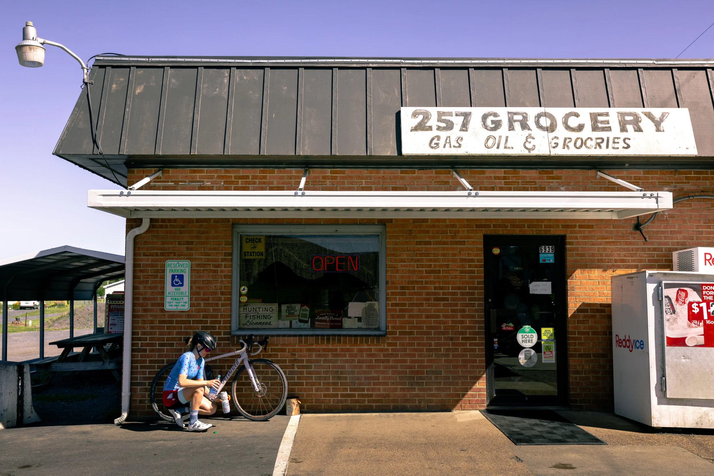
If you’d like some more mileage for your day, it isn’t unheard of for folks to ride out from town to do this loop. There’s plenty of snacks to grab at the 257 store in Briery Branch. :)
Ride Distance: 15.5 miles
Ride Elevation: 3,215’
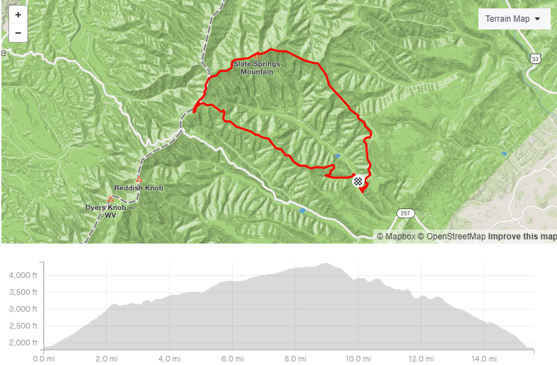

This ride begins with climbing Big Hollow to Hone Quarry Ridge.
Key Points
Big Hollow / Hone Quarry Ridge
After turning onto Trail 430 from Hone Quarry Road, riders will want to stay to the right at the first trail intersection to continue onto Big Hollow. Turning left would take you up Heartbreak, and you certainly would have no shortage of heartbreak after climbing those rocks! (It’s really rocky, steep, and crazy, haha).
Just slightly after climbing 2 miles, you’ll intersect with the top of Heartbreak (on the left). You’ll want to continue this route by staying to the right, but I also like to sit down here for a moment and eat a snack. The two miles you just climbed will have had a few creek crossings, loose river rocks, and some steeper uphills, so take a moment to recover. It’s worth it!
Also in those two miles you’ll have encountered what I like to call “Magical fairy, unicorn land”. Ferns, blueberry bushes, wild Dogwoods, and all sorts of plants/foliage are all over And SO many birds fly and tweet all around. The only noise comes from the wind in the trees and the birds; it’s quite peaceful. Right now seems to be especially beautiful as there was a controlled burn on the mountain a few years ago, opening up the forest floor and providing striking contrasts between new and old plant life.

Riders will reach this creek crossing early on Big Hollow. I’ve seen some ride it, or attempt to ride it, but I’m content with walking.

Big Hollow is so beautiful!

A remnant from the controlled burn

The intersection with Heartbreak/Trail 430
The Magical fairy unicorn land continues as you make your way onto Hone Quarry Ridge all the way up to Forest Road 85 (6.3 miles into the ride). Stay to the right as you intersect with this road and continue on for some fun and chunky double track to Meadow Knob (Mile 10.6). Watch out for some monster truck sized puddles! You’ll take Trail 428 (not marked super clearly) - it will be on your right towards the back of the meadow.
This section of trail will roll along with a few very steep downhills - I wouldn’t say there is anything technical in them aside from the steepness and maybe some loose rock. You’re not far from Cliff Trail after you pass the intersection with Pond Knob (Trail 428B); Mile 11.5.

MAGICAL FAIRY UNICORN LAND!!! :)

Cliff Trail
Around 12.5 miles into the ride, you’ll find the start of Cliff Trail on your right. You’ll look in front of you and see a steep climb - if you were to continue straight here, instead of turning right you would be at Oak Knob, which takes you to some other fun trails, but that’s a story for another time. Cliff Trail is designated with the Forest Service signage Trail 429.

ROCKS!
This trail is rocky! It is technical, and fun. There are parts of this trail that I don’t ride because it’s so technical and my abilities don’t match the terrain. And that’s fine! I ride within my abilities and push them when I feel comfortable, as everyone should. For just over 2 miles riders will be able to challenge themselves on all levels of rock gnar as they begin the descent down the mountain.
At mile 15, you’ll reach what’s known as the Lover’s Leap overlook - a beautiful rock outcrop that looks across to the other ridge. This is another spot I like to sit and hang out/eat a snack. There’s just 0.5 miles of descending left, so if you’re not quite ready to head back to society, stay here a while longer.

Wild Azaleas!

Lover’s Leap Overlook

I love the rock variety on Cliff Trail
Don’t think you’re done with the rock in that last half mile, though. Rocks and roots guide you down the trail, some bigger roots/boulders block the way (at least for me, I know of some folks that clear the bigger stuff on this), and a good time is had through it all!


Made it back down to Hone Quarry Rd
Why this Ride?
There’s something about this loop that feels extra special. The forest feels different - more back country, more open, more welcoming. The trails are different and offer variety - creek bed, to double track, to smooth single track, to some rock, to full on gnar! There’s no shortage of beauty on this ride; riders are well rewarded for the climbing and technical spots.
Extras
When Hone Quarry Campground is open, it offers several campsites of different sizes for folks and a low cost/night! It’s definitely a nice spot to stay for a long weekend!
Trails are maintained with the help of the Shenandoah Valley Bicycle Coalition, and other fine volunteers, and we thank them profusely for keeping these trails in great shape!
If you have any other questions about this loop, feel free to ask! Email me at kelly@rocktownbicycles.com.
Photo Credit: Jess Daddio


Reddish Knob
About
Reddish Knob is one of our most iconic bike rides. One of the highest peaks in Virginia, Reddish sits at 4,397’ on the state line of Virginia and West Virginia. You pass over the state line a few times as you arrive at the summit.
Our route is 58 miles with 4800’ of climbing, and includes beautiful views, rolling hills, and of course, the climb up Reddish Knob.
The 3200’ climb is well worth the effort - cyclists are rewarded with a 360 degree view of the Shenandoah Valley, the Blue Ridge Mountains, and the Allegheny Mountains.
For locals, summitting Reddish Knob by bike is almost a right of passage, or a bucket list ride to check off, and quickly turns into a regular Spring and Summer ride destination.
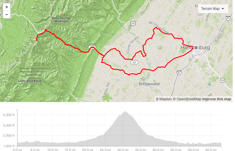
Click the image to visit the Bike Route

Key Route Points
Food & Water
One of our favorite local gas stations, the Briery Branch Store/257 Grocery can be visited twice on this route, if you so choose - once before the climb and once before heading home. It sits at miles 19 and 42, respectively. It has water, soda/pop, candy, snacks, chips… all the goods!
Briery Branch Reservoir
Keep an eye out for Bald Eagles, Indigo Buntings, Monarch Butterflies, and more! Right after you pass the reservoir, you’ll get a small descent, and then it gets real steep for a bit as you continue to climb up the mountain.
You’ll notice a “6” spray painted on the right side of the road. This designates the 6 miles remaining to reach the top of the climb. You’ll also see “5, 4, 3, 2, 1, and 0.5” as you make your way up the road. I think a lot of folks would agree with me that the “toughest” section is probably between mile markers 4 and 3. You cross to different sides of a ridge a few times and go around some steeper turns; the turns kind of play mind tricks on you and it always seems like you’re further than you are.
At mile marker 3, you’ll have half a mile before you reach the saddle and make the left turn off of Briery Branch Road to continue the rest of the way.


The Saddle
This is where you will turn left off the main road, and continue another 2.5 miles to the summit.
There will be some relief with a few downhills, but there are also a few steep buddies in there.
The views start to get really good after you make the saddle turn. Looking into West Virginia, in addition to the never ending mountain ridges, you’ll see some big satellites that were part of a Naval base - kind of cool; I believe they’re just communication satellites now.
Half a mile to go
You’ll know you have 0.5 miles to go when you are riding on the ridge of the mountain and can see views to both Virginia and West Virginia. It’s beautiful in every season, and always gets me extra pumped to reach the summit!

Reddish Knob:
Coming around that last turn you’re greeted by all sorts of fun graffiti - some goofy and happy, some sharing colorful words (haha) - it’s always fun to see what new art has been added! The view is magical, make sure you take it all in!


The descent & Return Home
With any ride we share, we encourage every cyclist to ride safely and within their means. All of the roads on this route are public and see some automobile traffic. The actual road to Reddish Knob is quite narrow, and though it is fast and beautiful, please watch for oncoming traffic. Also, the slower you go means the more views you’ll get to take in!
The beautiful riding doesn’t end after you have come down the mountain. Nazarene Church and Thomas Spring are two of my absolute favorite valley roads! And if you happen to catch a tailwind home, they are extra fun! :)

Extras
Strava Segments: The most popular segment individuals look at for the climb of Reddish Knob is called “Reddish Knob from the turn” and can be found on our route.
Reddish holds a special place in my (Kelly’s) heart. It’s one of the climbs I have come to know so well that I can remember all the surface changes, potholes, grade changes, and erosion spots for the entire climb. So if you have any other questions about this route, I’m more than happy to answer.
Favorite go-to snacks from the 257 Store - Cherry Coke, Salt & Vinegar Chips, and Watermelon Sourpatch Kids
Favorite Spray Paint/Graffiti so far - SPONGEBOB (the unicorn is a close second)!
All photos are by Jess Daddio.
